
 Location :
On the Chinese Loess Plateau (CLP), a megaproject titled “Gully Land Consolidation” (GLC) has been implemented in rural watersheds to offset the farmland loss induced by the “Grain for Green Program”.
The main goals of the GLC project includes reshaping creek valleys by incising foot slopes, filling stream channels and ditches, constructing drainage canals, dams and reservoirs, and creating flat farmlands.
The previous study found that, compared to a natural catchment, the soil nitrate increased significantly in the deep profile of the valley flat farmland in a reshaped catchment.
However, whether such valley reshaping, damming and agricultural land consolidation affect the surface and groundwater nitrate and pose a threat to local people remains unclear.
Recently, Prof. JIN Zhao’s team from the Institute of Earth Environment (IEE) of the Chinese Academy of Sciences conducted extensive field investigation and experiments to enhance the understanding of water chemistry, inorganic nitrogen and environmental isotope levels in a dammed watershed and a natural watershed, revealing how valley shaping and damming affect water nitrate level and source at watershed scale.
They found that nitrate concentrations in both the natural and dammed watersheds were lower than 10 mg·L-1, which was lower than the maximum contaminant limit of 10 mg NO3- L-1 set by the US Environmental Protection Agency (USEPA), among them the seasonal nitrate contents in the surface (0.42-0.52 mg·L-1) and groundwater (1.86-3.65 mg·L-1) of the dammed watershed were significantly lower than those of the natural watershed (surface water: 0.92-2.07 mg·L-1; groundwater: 2.73-8.21 mg·L-1).
Hierarchical cluster analysis (HCA) showed that there were strong interactions between the surface runoff and the reservoir water in the dammed watershed, while in the natural watershed, streamflow had a close relationship with the groundwater.
They also found that nitrate fertilizer, soil ammonium, and manure and septic waste were the main sources of nitrate in the surface water of two watersheds, while the nitrate in the groundwater mainly originated from the nitrification of soil ammonium and manure and septic waste. Compared to the natural watershed, the dammed watershed had increased inputs of agricultural fertilizers in the surface water. However, there was no significant difference in the groundwater nitrate sources between the two watersheds.
They considered that valley reshaping, damming and agricultural land consolidation significantly affected the input of each nitrate source and water quality of the surface water but had little influence on the groundwater.
Moreover, the study revealed that valley reshaping, damming and agricultural land consolidation could alleviate nitrate pollution and that dams and reservoirs built along the reshaped valley would play a key role in controlling the concentrations of water nitrate, which had global implications for watershed management and agricultural land consolidation.
However, although the current groundwater had not been influenced noticeably by GLC projects in the dammed watershed, the time lag between agricultural land consolidation and groundwater quality response should be considered in the future.
“A reasonable level of N application should be implemented in the dammed watershed to maintain the high-quality of the surface and groundwater”,Prof. JIN suggested.
This study aids in developing strategies for the comprehensive management of watershed and drinking water sources in rural regions worldwide.
This work, published in Journal of Hydrology, was funded by the National Key Research and Development Program (2017YFD0800502) and the National Natural Science Foundation of China (Nos. 41573067, 31700414). The authors declare no conflicts of interest.
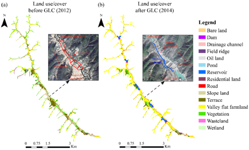
Fig. 1 Land use and land cover types in the valley of the treated watershed before and after the project of Gully Land Consolidation (GLC) project. The remote sensing images show that the valley flat farmland significantly expanded, and reservoirs were built in the creek bottom. (Imaged by YU Yunlong, et al.)
Contact: Bai Jie, Institute of Earth Environment, Chinese Academy of Sciences, Xi'an, China. Email: baijie@ieecas.cn
 © 2015 Institute of Earth Environment,CAS
 Address:No. 97 Yanxiang Road, Xi'an 710061, Shaanxi, China