
 Location :
The Yellow River (YR) is 5464 km long and the cradle of Chinese civilization. It is also well known for being the most sediment-laden river and having the largest vertical drop over its course. Although the YR accounts for only 3% of China’s water resources, it irrigates 13% of its cropland. Exceptional historical documents have recorded frequent occurrence of YR flooding events that resulted in huge losses of lives and property. As a result, successive Chinese governments of all historical periods set up special units to manage the YR, and make flood control the number one priority.
Since the start of the Anthropocene in the 1960s, an increasing number of large-scale dams and reservoirs have been built in the main YR channel. In addition to this, water consumption by agricultural irrigation along the YR middle course has risen sharply. Human activities have ultimately and irreversibly changed YR natural characteristics. Low-flow events have occurred frequently in recent decades, and there was even no water flow for several months each year in the lower YR course during1995–1998CE. Moreover, the sediment load of the YR has declined by approximately 90% over the past 60 years, which significantly affects the ecosystems and the delta morphology of the YR estuary. In this context, several questions are desperately in need of resolution: 1)What is the record of YR streamflow before observations began, and how does the current YR runoff compare to long-term stream flow variability? 2) How much water has been consumed by human activities? 3) Why has the YR become clearer recently? 4) Why has the sediment load decreased so greatly?
The earliest observational record of YR runoff, beginning in 1919 at the Shanxian gauge station, is too short to study centennial-scale variability. Since the start of the Anthropocene in the 1960s, frequent human activities, e.g. construction of dams and reservoirs, agriculture irrigation and industrial withdrawal have resulted in large deviation between observed streamflow. The reconstruction of annual historical natural runoff of the YR is necessary to quantify the amount of anthropogenic YR water consumption in recent decades. Tree rings, with the merits of accurate dating and annual resolution, have been widely used in runoff reconstruction worldwide. In this study, 31 moisture-sensitive tree-ring width chronologies (Fig. 1), including 860 trees and 1707 cores (Fig. 2), collected within the upper-middle YR basins were used to reconstruct natural runoff for the middle YR course over the period 1492–2013 CE (Fig. 3). This study was mainly carried out by Prof. LIU Yu and his team from Institute of Earth Environment, Chinese Academy of Sciences. Researchers from the Laboratory of Tree-Ring Research, the University of Arizona, Xi'an Jiaotong University, Chang’an University and Institute of Soil and Water Conservation, Northwest A&F University were also involved in this study.
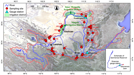
Fig. 1 Thirty-one tree-ring sites (red dots) in the middle-upper reaches of the Yellow River (YR). Thick blue line denotes the YR, while the thin blue lines denote the large tributaries the YR; blue triangles represent the streamflow gauge stations in the main channel, namely, Toudaoguai and Shanxian; the green shaded areas are irrigation districts. The map in the lower right corner shows the area of the Sanmenxia Reservoir. (Imaged by LIU Yu, et al.)
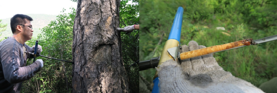
Fig. 2 Tree-ring sampling and tree core. (Imaged by LIU Yu, et al.)

Fig. 3 Hydrological year (previous August to current July) runoff reconstruction at the Shanxian gauge station of the Yellow River. Comparison between the observed (blue) and the reconstructed (red) runoff. The black curve is the 11-year moving average of the reconstruction. The blue curve superimposed on the reconstruction denotes the observed annual runoff from 1920 to 2013 CE. The shaded area represents the ±2 standard error bars. The short pink horizontal line (lower right) represents the average observed runoff from 1987 to 2013 CE. The solid gray horizontal lines indicate the mean value of the reconstruction, and the boundaries for extremely high/low runoff, respectively. The dashed gray horizontal lines indicate the boundaries for high/low runoff, respectively (see Methods). (Imaged by LIU Yu, et al.)
The reconstruction provides a record of natural YR runoff variability prior to large-scale human interference. Most of the extreme high/low runoff events in the reconstruction can be verified with historical documents. The lowest YR flow since 1492 CE occurred during 1926–1932 CE, with are constructed average annual runoff of 298×108 m3, and the YR runoff in 1781 is the highest, with 588×108 m3. These two extreme values could be regarded as a benchmark for future judicious planning of water allocation. The observed low YR runoff since the late 1980s has exceeded the natural range of runoff variability and was caused by a combination of decreasing precipitation and increasing water consumption mainly by direct and indirect human activities, particularly agricultural irrigation. Since the late 1980s, observed YR runoff has fallen out of its natural range of variability, and there was even no water flow for several months each year in the lower YR course during 1995 to 1998.Especially concerning was that the inherent 11-year and 24-year cycles of YR became disordered following the severe drought event in late 1920s, and eventually disappeared after the 1960s.
Year-to-year variability in YR water consumption by human activities (WCHA) was quantified, which showed good association between crop yields and acreage in Ningxia and Inner Mongolia irrigation regions. Agriculture consumes most of the YR’s water, but with relatively low crop productivity. Meanwhile, WCHA was strongly negatively correlated with sediment load at Toudaoguai and Shanxian stations, which led to a 58% reduction of sediment load in Toudaoguai (upper reach) and 29% in Shanxian (middle reach).The decreasing runoff and water volume in YR weakened hydrodynamic forces, thereby attenuating the capacity of sediment transport and enhancing sediment deposition. These factors reduced sediment load and clarified the water in the YR main channel. In addition, other studies revealed that government-sponsored measures, such as construction of tens of thousands of check dams, soil and water conservation, and afforestation on the Loess Plateau, also contributed to the reduction of the YR sediment load.
If human activities continue to intensify, future YR runoff will be further reduced, and this will negatively impact agriculture, human lives, and socioeconomic development in the middle and lower basins of the YR. To reduce the risk of recurring cutoff of streamflow in the YR lower basin, water should be allocated judiciously. Cautious policy can balance water allocation among the needs of agriculture, industry and ecosystems. From this point of view, our reconstructed YR natural runoff series are important for future YR water resource management. In addition, our results also provide an important model of how to distinguish and quantify anthropogenic influence from natural variability in global change studies.
This work was supported by the Chinese Academy of Sciences, National Natural Science Foundation of China et al.
This paper was published online in the Proceedings of the National Academy of Sciences of the United States of America (PNAS) on July 20, 2020.
Contact: LIU Yu, the State Key Laboratory of Loess and Quaternary Geology, Institute of Earth Environment, Chinese Academy of Sciences, 710061 Xi’an, China, email: liuyu@loess.llqg.ac.cn
 © 2015 Institute of Earth Environment,CAS
 Address:No. 97 Yanxiang Road, Xi'an 710061, Shaanxi, China